Dorking Street O
Tuesday 17th September
Entries are closed!

This is the first event in a series of 8 Street O Events that MVOC are organising.
These events are a great introduction to orienteering for runners of all abilities and a good opportunity to get out and about midweek for a bit of training.
The Winter Street O Series will run between September and April at local venues within the Mole Valley area.
All events will take the form of a score course. Your map will show a number of controls but you don't have to visit each one. This means that there is no set course, you just visit as many controls as you can within a 60 minute limit. A 40 minute option is also available for those who feel they are unable to complete the full hour.
Start and Finish will be located in the outside area of a pub which will also offer food - a great opportunity to meet your fellow competitors afterwards and chat about the course.
Online entries close 4pm on the day of the event but please get entries in early for map printing purposes.
If the event is cancelled, a refund of your entry fee will be made after the deduction of unavoidable expenses incurred by the club.
All events will take the form of a score course. Your map will show a number of controls but you don't have to visit each one. This means that there is no set course, you just visit as many controls as you can within a 60 minute limit. A 40 minute option is also available for those who feel they are unable to complete the full hour.
Start and Finish will be located in the outside area of a pub which will also offer food - a great opportunity to meet your fellow competitors afterwards and chat about the course.
Online entries close 4pm on the day of the event but please get entries in early for map printing purposes.
If the event is cancelled, a refund of your entry fee will be made after the deduction of unavoidable expenses incurred by the club.
Courses
60 minute Score
Entered: 0
The main course - points awarded for all controls visited with a time penalty of 1 point per 2 seconds late.
40 minute Score
Entered: 0
Optional shorter time limit for those not able to complete the full hour course or possibly for novice/juniors. Net Score after penalties will be multiplied by 150% and appear in the main results.
Entry Fees
From 29th July:
Member of an O Club/Non-member
Entry Fee: £3.50/£5.50
Mole Valley Member
Entry is free
Member of an O Club/Non-member
Entry Fee: £3.50/£5.50
Mole Valley Member
Entry is free
Event Information
Venue
Start, Finish and post race refreshments will be at the King's Arms pub, 45 West St, Dorking RH4 1BU
Start, Finish and post race refreshments will be at the King's Arms pub, 45 West St, Dorking RH4 1BU
Map
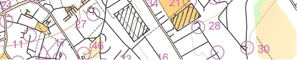
The map will be 1:10,000 scale - created from OpenStreetMap (see example above)
The map will be 1:10,000 scale - created from OpenStreetMap (see example above)
Timing
The event will be set up on MapRun (and MapRunG for some smartwatches).
If using MapRun, please ensure you are using the latest version of the app (MapRun7) and arrive on the night with the course pre-downloaded from the folder UK > Mole Valley > Winter StreetO 24-25 Winter Series.
If using MapRunG, you will not need the PIN.
Our strong preference is for everyone to use MapRun, but those who do not want to or are unable to use MapRun can handwrite their answers with a pen or pencil and timing will be by a punching Start and Finish.
The event will be set up on MapRun (and MapRunG for some smartwatches).
If using MapRun, please ensure you are using the latest version of the app (MapRun7) and arrive on the night with the course pre-downloaded from the folder UK > Mole Valley > Winter StreetO 24-25 Winter Series.
If using MapRunG, you will not need the PIN.
Our strong preference is for everyone to use MapRun, but those who do not want to or are unable to use MapRun can handwrite their answers with a pen or pencil and timing will be by a punching Start and Finish.
Safety
U16s must be accompanied by an adult.
Competitors are asked to wear high visibility clothing, reflective strips and/or additional lighting devices and carry a whistle for attracting attention in case of an emergency.
U16s must be accompanied by an adult.
Competitors are asked to wear high visibility clothing, reflective strips and/or additional lighting devices and carry a whistle for attracting attention in case of an emergency.
Starts
6.30 - 7.30 pm. Courses close at 8.40 pm sharp.
6.30 - 7.30 pm. Courses close at 8.40 pm sharp.
Travel
Dorking West station 0.7km, Dorking (Deepdene) station 1.3km, Dorking station 1.5km. 465 bus from Kingston stops nearby (and return bus to Kingston stops outside the pub).
Town centre car parks nearby and some free evening street parking available within a short walk. Please note that West Street is closed for traffic and this is causing large congestion to roads in Dorking. Drivers are advise to approach from the East and park in either Mill Lane or Southside Car Parks.
Dorking West station 0.7km, Dorking (Deepdene) station 1.3km, Dorking station 1.5km. 465 bus from Kingston stops nearby (and return bus to Kingston stops outside the pub).
Town centre car parks nearby and some free evening street parking available within a short walk. Please note that West Street is closed for traffic and this is causing large congestion to roads in Dorking. Drivers are advise to approach from the East and park in either Mill Lane or Southside Car Parks.
Results
Will be available on the MapRun app when all have finished and on the club website as soon as possible after this event.
Will be available on the MapRun app when all have finished and on the club website as soon as possible after this event.
Conduct
Please make yourself aware of and follow the British Orienteering guide for participants (revised September 2022).
Please make yourself aware of and follow the British Orienteering guide for participants (revised September 2022).
You are responsible for your own safety and you take part in this event at your own risk.
